Sunday, April 25, 2010

Massawa - Center of the Red Sea & World


Get some PERSPECTIVE
City: Massawa Part 1 Islands: Batse and Tualud Country: Eritrea Region: East Continent: Africa


Massawa is one of two port cities in Eritrea bordering the Red Sea. Historically and culturally speaking Massawa has remnants of its ancient influence on the world as well as the world’s influence and ambition for it. Traveling the islands in between causeways, the remnants of the many ancient and present-past colonizers imposition on Massawa give the city a distinct disposition, a timeless city that has seen raiders of its desire and its devastation.

A Lesson in Histories

What is now Massawa in ancient times was known as the port city of Adulis. Adulis is one of the first known world ports and trade centers dating back as far as 3rd Century B.C. Trade occurred between Adulis, the Middle East, the Far East, Greco-Roman and the Western world. Adulis ushered in the emergence of the East African city-states as this port enabled the trading and commerce necessary to create the Axumite Kingdom and other inland city-states in present day Eritrea like Kohito, Keskese and Metera.

To understand the history of Massawa is really to understand the history of the entire Eritrean experience and its relation to the world. Below is a general timeline of what the city of Massawa has endured.

  1. 7th Century AD - The spreading of Islam in the Dahlak Islands, migration from the Arabian Peninsula and presence of the Persians in the Red Sea Area.
  2. 8th – 13th Century AD - The many Beja Kingdoms running from the Nile Valley to the Red Sea Coast
  3. 15th century - Midri Bahri (Land by the Sea) ruled by Bahri Negassi (Lord of the Sea) these were locally elected pockets of administration in and by what are now the Eritrean highlands. The capital of Bahri Negastat was Debarbwa.
  4. 1557 - The arrival of the Ottoman Turks and the Turkish Empire in Massawa and administration of the sea coast and ports
  5. Abyssinia’s desire for the highlands and overthrow of Bahri Negassi led to the alliance of the Portuguese (their desire was to overthrow the Turks and control Massawa)
  6. The Turkish Empire rules the lowlands for 300 years
  7. 1872 - The Egyptian Empire controls Massawa and parts of lowland Eritrea displaces the Turks
  8. 19th century - Abyssinian expansionism (Tigrean and Amhara) begins to take presence in various parts of Mere Milash (Eritrea)
  9. 1884 - treaty ends the Ethio-Egyptian scramble for Eritrea
  10. 1885 - Berlin Conference and Scramble for Africa during WWI leads to the Italian colonization of Eritrea and occupation of Massawa
  11. 1941 - British military administration of Eritrea, est. a military base in Massawa
  12. 1950 - By the auspices of the United States Eritrea is federated with Ethiopia (its political ally) by the United Nation General Assembly
  13. 1952 - US enjoys a naval base in Massawa
  14. 1962 – Ethiopia dissolves federation and announces Eritrea as part of the Ethiopian Empire
  15. 1961 – Armed struggle to free Eritrea begins by ELF (Eritrean Liberation Front)
  16. 1975 - Hirgigo Massacre by the Dergue military junta in Ethiopia during the Eritrean Liberation Struggle
  17. 1977 – Massive attack by sea, air and land by the Soviet Union and Ethiopia (Dergue regime) kills innocent civilians, destroys 90% of Massawa’s infrastructure
  18. February 1990 – EPLF (Eritrean Peoples Liberation Front) forces liberate Massawa through Operation Fenkil

The Island of Batse

On the island of Batse you will find two main attractions, the Ports of Massawa and Old Town all encircled by the Red Sea. Massawa was and still is a strategic geopolitical area. It is also the largest deep-water port on the Red Sea. The ports of Massawa and Assab (the other port city in Eritrea) are now developing into Free Trade Zones for small businesses all over the world.

Old Town includes shops, restaurants, cafes and bars. Its architecture is influenced by the Turkish and Egyptian presence on the coastlines. Some say the Egyptians used bricks while the Turkish used other decorative art like the photos below.

While the structures are as old as the empires that left them, renovation has begun on the interior.

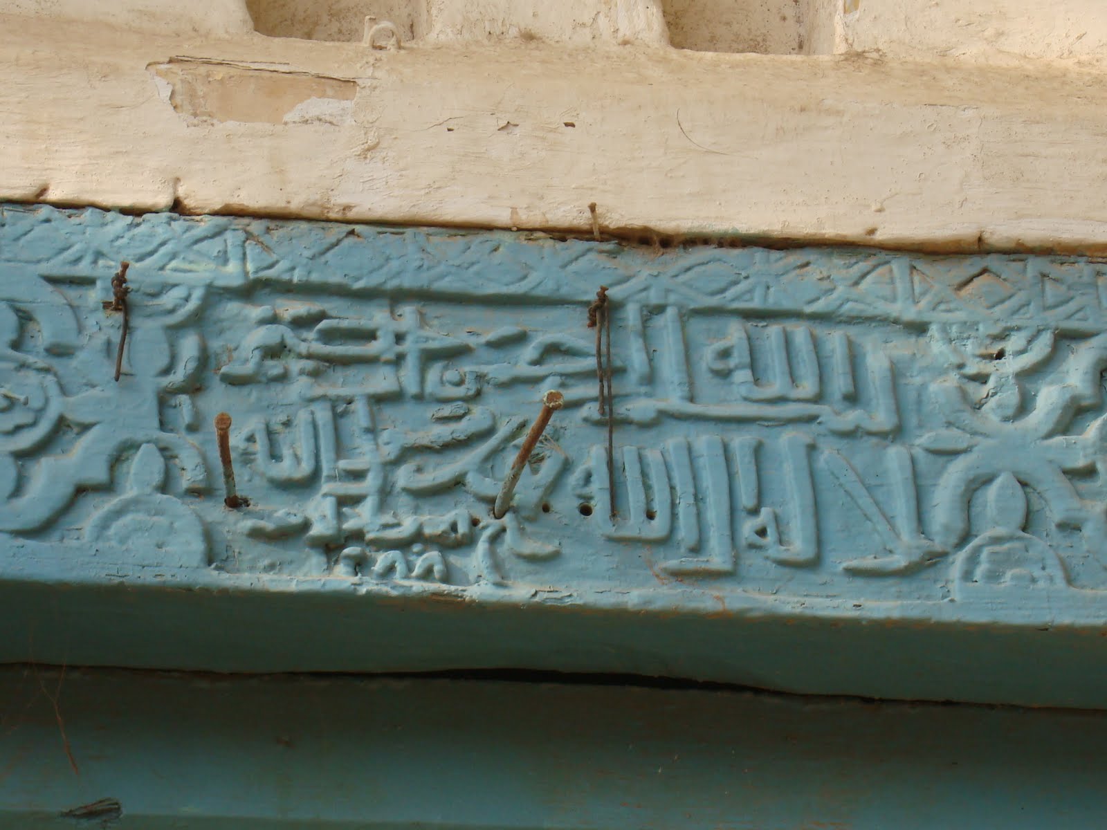
PHOTO: Despite some reporters’ observations of Massawa being “undeveloped”, monuments like this one are left as a reminder of the destruction and toll Massawa has endured throughout the years. Nearly 90% of the city was destroyed by the Dergue regime (Ethiopian) during the Eritrean liberation struggle.

PHOTO: Abdelkadir Kebire's Tomb looking out onto the Red Sea.

Abdelkadir Kebire was one of the founding fathers of the "Eritrea for Eritreans" political party during the British administration of their country. A representative from Dahlak, he was a prominient speaker and political influence in Eritrean society. He was assassinated at the city center the day before he was to visit New York to address the UN General Assembly in regards to Eritrea and his parties stance for an independent Eritrea.


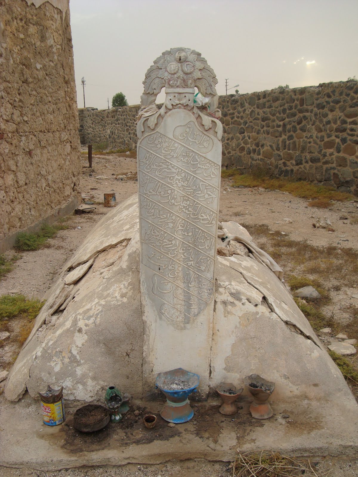
To this day people bring coffee and other gifts to remember him.

The Island of Tualud

The War Monument of Operation Fenkil – The three tanks facing the linking causeway as you enter Tualud is a statue of the exact place where the EPLF tanks halted in February 1990 when finally liberating Massawa. It also serves as the memorial site for the many civilians and martyrs that sacrificed their lives in Massawa.

PHOTO: National Holiday February 10: Operation Fenkil Anniversary


On this island you can find several inland hotels. Including the newly inaugurated Grand Dahlak Hotel. Previously Dahlak Hotel it was reconstructed. It has now become a primer attraction and destination stay.

PHOTO: Offices Twin Towers

PHOTO: Imperial Palace of HaileSelassie

Sunday, April 18, 2010

On the ROAD to Development


Get some PERSPECTIVE
Area: Durfo Country: Eritrea Region: East Africa

Durfo is located nine to ten kilometers northeast of Asmara. A side note about Asmara, it is amongst the highest capital cities in the world with an elevation level over 2300m. Durfo is also known as Durfo escarpment. Meaning this area has sharp and steep elevation differences, or a very steep slope. In the case of Durfo the elevation drop is between 1500 –1000m. The cloud in this photo was visible from near the top of the escarpment. Imagine looking down at the clouds. I keep thinking if I came to Eritrea just a few months earlier I may have never gotten to take this picture or take in this view.

PHOTOS: From the TOP to the BOTTOM

The road we drove down was developed just three months ago. For example the newly constructed Beleza-Durfo Road. The inhabitants of these remote areas now can travel quickly and safely from the bottom to the top of this area. More than pictures, from a development standpoint this is a huge accomplishment.

At the bottom of the escarpment there is a school and located beside it a papaya tree farm. Many of the people living in this area use camels and donkeys to transport these goods to people who live in and throughout the area. These are highly regarded domesticated animals that are an integral part of many societies living in Eritrea. Technologically speaking it may seem counterproductive to use these means, but those who observe in this way do so in jest. To experience nature of this magnitude is to really appreciate the natural command and employ of such animals.

In areas with such an uneven landform like Durfo the construction of these roads are instrumental in bridging the gap between the rural and city areas. Construction of new roads is a pivotal project taken on throughout Eritrea, as you will see in later posts.

This photo is of colonial Italian infrastructure. An electrical pipeline to generate electricity to the bottom of the escarpment.

From an historical context Durfo was a strategic site during the Eritrean Liberation Struggle, in particular Adi Reasi. Which is a far off mountain that is visible from the other side. It’s name as a literal translation means “Village Atop/Head”. This is when Eritrean freedom fighters were trying to re-liberate areas taken during the liberation struggle (which lasted 30 years, the longest conflict in African history) and move towards the liberation of Asmara from occupying forces.

PHOTO: A walk in between the clouds.

Wednesday, April 7, 2010

Asmara – A Mosaic of WORLD Culture and History

Get some PERSPECTIVE

Neighborhoods: Tiravolo, Tsetserat, Sembel, Downtown

City: Asmara Country: Eritrea Region: East Continent: Africa

The car in this photo is an old model Fiat (an Italian automaker). The palm trees and shiba’kha trees laced across Asmara create a metropolis of shade and visual paradise. Asmara’s architecture is nothing short of a cultural melting pot.

Africa’s Secret Modernist City is a newly termed description of the many awe inspiring Modernist style buildings and Art Deco buildings from the past. One of the most infamous sites in Asmara is the Fiat Tagliero building located in the Compobolo district of Tiravolo. It is reminiscent of the Futurist Style designed by Giuseppe Pettazzi in 1938. Originally it was a service station it may now become a disco. Pettazzi an Italian architect along with creating an infamous building and structure has been infamously quoted as saying he would kill the main builder in 1938 if he and the construction workers did not remove the support beams from beneath the wings of the structure. Confident in his design some 70 years later the Fiat building still stands. The wings are the most defining part of his Petazzi’s work. If you look to the left of this photo you will notice a bird also in the shot in flight with wings spread apart just like the Fiat building!


The Irga building is a colorfully simple building. It was erected in the 60’s. It is located next to the Fiat building on the round about circle on the intersection of Sematat Avenue and Mereb Street. Both buildings also have their names spelled out in Tigrigna script (one of the nine languages found in Eritrea). Fiat written at the top, Irga written to the left.


In 1999 the Government of Eritrea created CARP the Cultural Assets Rehabilitation Project. Asmara is in the ongoing process of being listed as an UNESCO World Heritage Site and has been recognized as a city that is full of historical and worldly sites. CARP is working on ensuring these sites get proper restoration and recognition in the future.

PHOTO: A parked bike at Il Teatro (1920's) now Asmara Theatre (Opera House).
Bicycles are parked throughout Asmara.

The newer urban development designs in the district of Tsetserat are a fusion of the past and the present styles including the developments known as “da German” (known for mostly being owned by Eritreans living in Germany), as well as a neighborhood in the district known as Space. The Sembel Residental Complex (“da Korea”), which was built by a Korean contractor Keangnam Enterprises in 1996, is located in Sembel.


Below are NSEW views of Asmara. I was able to capture these photos from atop the Cathedral in the city center of Asmara on Harnet Avenue (more on the Cathedral later). It is not common knowledge that anyone can get access to the top of this building. You will have to find the guard of the building and ask him if you can climb to the top of the bell tower. It will cost you 10 Nakfa (Eritrea’s currency).

Climbing up is the hardest part.
If you are weary of heights and tight spaces then I highly recommend that you do NOT go up.

PHOTO: Proceed at your own risk.

It requires a lot of maneuvering and adventurism on your part, but the view is unlike any in and around Asmara.


PHOTO: Bells of the interior tower of the Cathedral


The bell toll at 6PM and the sun beginning to set on the city.


Thursday, March 18, 2010

Get some PERSPECTIVE

Neighborhood: Tiravola Part 1
City: Asmara Country: Eritrea
Region: East Continent: Africa

Do I blog. No. As a writer its never been my thing. So why now? Pictures and traveling are my thing. I decided to start a blog to document my Eritrea. Also to help guide others interested in visiting and learning more about Eritrea, a country off the Red Sea coast of East Africa. I decided to include a photograph of what I now dub my reading/writing corner here in Asmara, the capital of Eritrea. This is Expo Hotel. One of the first hotels to start operating i n an independent Eritrea (1991) in the mid-nineties. Designed and owned by an Eritrean businessman
known as "da Sedusto". It's now located on Bada Street, which was renamed as it previously was called Addis Abeba Ave. under Ethiopian colonization. (Addis Abeba is the capital of Ethiopia).

Expo Hotel is located in Tiravolo a neighborhood that is heavily influenced by Italian colonization. (Really all of Asmara is, as Asmara's art deco is that of a colonial city full of old Italian archetectual designs.
Eritreans however, built all buildings).

Occupation by Italians occurred during the Scramble for Africa by European powers. In 1885, Italy ousted the previous occupiers, Egypt. (They mostly occupied the coastal areas of Eritrea). There was a strong resistance by Eritreans and an uprising occurred lead by Bahta Hagos. Despite the resistance Eritreans were forced to abide by Italian policies in their own land. Italy's objective at the time was to create an "African v. of Italy" in where Italian farmers, families and society in general would migrate to Eritrea to live. This is during the World War eras and as a result of the infighting that was happening between Europe. Other Italian colonies included Libya and Somalia. In Triavolo you will find streets upon streets of Italian deco villa homes. Pretty buildings aside, this is also a reminder of Mussolini and Co. bringing facism into Eritrea's backyard and Italy's ambition for Eritrea.


Triavolo is home to the following embassies, Canada, China, Qatar and the Red Cross.
If you are looking for a route to run or walk try walking up Warsai Ave. towards Allascalla Hotel. Turn right and walk up Fah Street. Here you will find a church called Enda Jesus (pronounced in Tigrigna enda ye-sus).


Keep straight and you will find villas, palm trees and Asmara suburbs all around you.

Eritrea is known for its numerous cafes and delicious coffee. There is always a cappuccino, macchiato, or espresso waiting right around the corner.

Drink up.


Restaurants in Tiravolo: Expo Hotel Rest., Hanish, Golden Fork and Family Ayele

Photo: The side of the Polytech building on Warsai Avenue.